Last day of work was Friday (tears mixed with joy) and Saturday morning found me hopping aboard a flight to Phoenix. Can I give a shout out to Southwest?
 I love how airline employees are adding humor to their boring safety speeches. On this flight, I laughed multiple times at a flight attendant’s comments but what had me chuckling was when we landed in Phoenix. After touching down, the plane was still moving quickly across the tarmac. After a good 20 seconds of not slowing down, the captain (maybe a flight attendant) came over the intercom and goes, "whoooooooaaaaaaaa Nelllllllly", accent included. Hah So fun!
Amber picked me up at the airport and we hit the road for Moab. Initially, we planned to visit Sedona and the Grand Canyon first, ending with Moab, but decided to complete the long drive first (great foresight!).
 Driving to Moab, we saw signs for Four Corners, so of course we had to take the hour detour. Paid our $5 (cash only!), walked around for 20 minutes, then took the iconic photo. Caution: time change if driving from AZ. We arrived twenty minutes before they shut down at 6:45pm. Phew! Barely made that one. Could you imagine if we arrived after they closed? A waste of an hour detour! *Luck was on our side*
Arrived in Moab in time for dinner. Such a cute town! Touristy but adorable. Car camped it in the grocery parking lot (say it with me…freee!), then rose with the sun to visit Dead Horse Pointe State Park which was en route to Canyonlands National Park.
We arrived at the gate to a sign that said to write our information on an envelope, place our money inside, and place envelope in the collection box. A huge sign at the front of the gate showed how much we were to pay if we were a tour group, single traveler, camping, etc. I love that they use the honor system, but I wonder who ignores it and just enters? Paid $15 to the State Parks of Utah (look at us, showing our honor) and entered.
We stopped at the visitor center to fill our water (huge plus to traveling from park to park, they all offer easy methods of filling water bottles or packs) and spoke to the Park Ranger. He told us what to do at DHP, Canyonlands, and Arches, so we were able to visit all three in one day.
 Left the visitor center and the views were so beautiful, we had to stop to do a some yoga/stretching on a cliff. (Side note: car camping isn’t for the over 30, even if we were able to stretch out in the back. Highly recommended: sleeping pads). Breathing in the fresh mountain air, we took in our first scene of beautiful canyons and switchbacks. We drove to the scenic view at the end, walked a bit, then took the iconic photo before heading to Canyonlands.
 Canyonlands was gorgeous. We turned onto White Rim Road, which was awesome (and a little scary if you're afraid of heights), but well worth it for the views. We drove for about 20 minutes on a narrow dirt road that was a sheer drop into the canyons. No railings. Nothing to stop you if (for whatever reason) you decided not to pay attention and drove over the edge.
After about 15 minutes, a Jeep came up from the canyon and was heading towards us. The road was so narrow that we weren't sure they would be able to pass us. Luckily, we were on the side that hugged the cliff wall, while they had to pass on the side that was the sheer drop. We waved them down and asked if they thought our vehicle would make it down into the canyon (2016 Ford Escape). The driver asked if it was a rental, then laughed after Amber said she owned it. He told us not to try it. So, we drove a few more minutes until the path widened and we could turn around safely.
 We drove back to the main path then stopped at the 1/4 mile Mesa Arch path. It was a little rugged and over uneven surfaces but quick and easy. The view through the arch was beautiful. Next, we went to the Grand View Point Overlook. The Park Ranger at Dead Horse told us to walk the mile to the lookout for the better view. He was right; well worth it. The hike was easy to moderate but has up and down stairs and can be difficult when hot. Unfortunately, there was a smudge on my phone lens, but I didn't realize it until I was back in the car, because you know, the sun. It was so bright, we couldn't see anything on our screens, and could only hope that the photos turned out well. So yeah, those ones didn't turn out. *tear* You'll just have to make the trip yourself one day!
 Lastly for the day, we visited Arches National Park. If you have to skip a national park due to whatever reason, this would be the one I recommend. All the parks we visited had an arch of some sort, so we didn't feel Arches offered anything new or different. Also, the Balanced Rock was not the most precariously balanced rock we saw either.
 However, I enjoyed the Delicate Arch hike. We did the Upper Viewpoint hike (1 mile, difficult), rather than the longer path as the Rangers advised it was too hot for the 3 mile hike (it was roughly 3pm and 102*, and the rangers "frequently rescue[d] people who underestimated the trail's difficulty."). It was great because we got in a decent workout in about 15 minutes.
A positive note about Arches: their water! It was purified, filtered and absolutely delicious! Remember to fill up all your bottles if you’re passing through.
 After Arches, we drove to Capitol Reef National Park, roughly 2.5 hours. (Random exciting fact: after turning onto interstate 70, the speed limit jumped to 80! Woot!). We were able to see the majority of the park during our drive into the town of Torrey as well as the sunset! We treated ourselves to a hot meal at the Capitol Reef Inn, where we spent the night. Yay hot showers and a bed!
 Capitol Reef NP: great hike! We took the scenic route out to Capitol Gorge Road then hiked the Capitol Gorge Trail. It was spectacular to be down in the gorge, looking up. There was one part of the trail where people from the 1800's had carved their names in the rock and the date they passed through the gorge (e.g. M Larson Nov 20 1888). It was neat to stand in the same place as these pioneers and imagine their excitement and fears as they travelled west.
We took The Tanks trail up which was awesome as we had to climb over rocks (not really a trail), and follow the various stacks of little rocks. Overall: the trail was not difficult and there was plenty of shade.
After our hike, we stopped at Gifford House and rewarded ourselves with homemade ice cream, refilled our water, then hit the road for Bryce Canyon.
 Scenic Byway 12: We stopped at the Wildcat Guard Station and spent twenty minutes speaking to two rangers. They gave us a Scenic Byway 12 guide, which listed 26 stops along the route to Bryce, with Capitol Reef being number 25, and Bryce Canyon being number 4. Of course we had to explore everything in this guide, right? Suffice it to say this two and half hour trip took us a lot longer, as we stopped at the majority of the places listed: every overlook (yes, every), scenic routes, cities, museums, and visitor centers.
 We saw cows, chipmunks, and more cows (no llamas even though the museum attendant promised). We drove over the Hogback, which is a winding road that drops off 1,000 feet on both sides of the road (gulp!). We drove through elevations of over 10,000 feet and back down to 4,000 feet. Our favorite? The Dixie National Forest. Thankfully, we would enter this massive forest multiple times over the next few days. I’m thinking my stopping point could be in a forest, by a lake. One step closer!
 Bryce Canyon: made it here in time to watch the sun set at Bryce Pointe. Gorgeous. It was just beyond the tree line and with the additional clouds, great viewing. As the temps were supposed to drop into the 50’s, we again camped in our car (side note: black bears roam BC, so we felt compelled to Google bears attacking cars when they smelled food. Hey, it’s a real thing and we didn’t think to ask a ranger. Luckily, google said we don’t have to worry about it where we were in Bryce, but I do need to prepare myself (and my car) for when I visit Yellowstone, Yosemite, etc. Any suggestions on the best bear canister to fit my food and smell-good toiletries?).
 For sunrise, we drove to Inspiration Point, recommended by the rangers. The sunrise was beautiful (and quick!) but I likely wouldn’t wake up for it again.
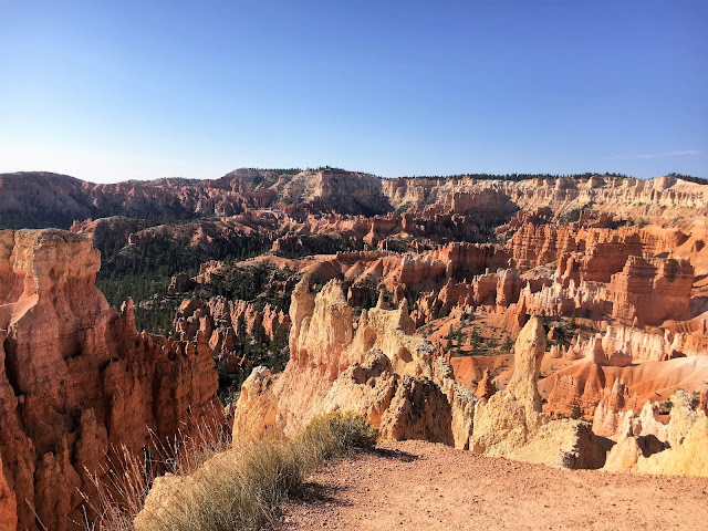
 We then hiked the Navajo and Queens Garden Trails, starting the decent on the Navajo side which was a winding trail through all the hoodoos (according to nps.gov, hoodoos are tall, skinny spires of rock that protrude from the bottom of arid basins and “broken” lands, likened to a “totem pole-shaped body”.). It was awesome. There was also sign that cautioned hikers to be vigilant over the next .5 miles, because this trail was where the most injuries (and deaths!) occurred in the park, due to falling rock. Some of the previously fallen rocks were car size. Suffice it to say, I was vigilant, while amber kept singing...loudly. Sigh.
 The trail eventually leveled out and the hoodoos were intermingled with various green trees. The end of the trail was all white sand. Overall a great park and hike. About 3 miles. The hike up was intense and steep, but before that, super enjoyable.
Oh, food, you're probably wondering what we've been eating. We stopped at Trader Joe’s before leaving Phoenix and each bought about $50 worth of groceries: jerky, jerky, and more jerky, apple sauce in packets, (okay, fine, I’ll admit, it was actually baby food…delicious baby food, and perfect for breakfast.), dry cereal, bread and squeezable honey, LARA bars, dried plantains, nuts, bananas, and apples. We didn’t have a cooler, so that restricted our shopping list. Overall, I ate dinner three times in a restaurant over the 9 days, but chose to eat the food I bought for all other meals, which cut down costs tremendously. Although, I must mention that Amber ate dinner at The Lodge at Bryce Canyon Restaurant and ordered the Stillwater Canyon Skirt Steak. It was absolutely delicious! It made me want to almost double my food spending money so I could order my own steak, even though I had just eaten a slice of bread with honey (oh yum, bread with honey, sooooo good).
Next: Zion!

Amber picked me up at the airport and we hit the road for Moab. Initially, we planned to visit Sedona and the Grand Canyon first, ending with Moab, but decided to complete the long drive first (great foresight!).

Arrived in Moab in time for dinner. Such a cute town! Touristy but adorable. Car camped it in the grocery parking lot (say it with me…freee!), then rose with the sun to visit Dead Horse Pointe State Park which was en route to Canyonlands National Park.
We arrived at the gate to a sign that said to write our information on an envelope, place our money inside, and place envelope in the collection box. A huge sign at the front of the gate showed how much we were to pay if we were a tour group, single traveler, camping, etc. I love that they use the honor system, but I wonder who ignores it and just enters? Paid $15 to the State Parks of Utah (look at us, showing our honor) and entered.
We stopped at the visitor center to fill our water (huge plus to traveling from park to park, they all offer easy methods of filling water bottles or packs) and spoke to the Park Ranger. He told us what to do at DHP, Canyonlands, and Arches, so we were able to visit all three in one day.


After about 15 minutes, a Jeep came up from the canyon and was heading towards us. The road was so narrow that we weren't sure they would be able to pass us. Luckily, we were on the side that hugged the cliff wall, while they had to pass on the side that was the sheer drop. We waved them down and asked if they thought our vehicle would make it down into the canyon (2016 Ford Escape). The driver asked if it was a rental, then laughed after Amber said she owned it. He told us not to try it. So, we drove a few more minutes until the path widened and we could turn around safely.


A positive note about Arches: their water! It was purified, filtered and absolutely delicious! Remember to fill up all your bottles if you’re passing through.


We took The Tanks trail up which was awesome as we had to climb over rocks (not really a trail), and follow the various stacks of little rocks. Overall: the trail was not difficult and there was plenty of shade.
After our hike, we stopped at Gifford House and rewarded ourselves with homemade ice cream, refilled our water, then hit the road for Bryce Canyon.


Oh, food, you're probably wondering what we've been eating. We stopped at Trader Joe’s before leaving Phoenix and each bought about $50 worth of groceries: jerky, jerky, and more jerky, apple sauce in packets, (okay, fine, I’ll admit, it was actually baby food…delicious baby food, and perfect for breakfast.), dry cereal, bread and squeezable honey, LARA bars, dried plantains, nuts, bananas, and apples. We didn’t have a cooler, so that restricted our shopping list. Overall, I ate dinner three times in a restaurant over the 9 days, but chose to eat the food I bought for all other meals, which cut down costs tremendously. Although, I must mention that Amber ate dinner at The Lodge at Bryce Canyon Restaurant and ordered the Stillwater Canyon Skirt Steak. It was absolutely delicious! It made me want to almost double my food spending money so I could order my own steak, even though I had just eaten a slice of bread with honey (oh yum, bread with honey, sooooo good).
Next: Zion!
Comments
Post a Comment